Eyr – A new generation of innovative, future-proof GNSS RTK receivers with dual cameras
CLICK HERE TO DOWNLOAD THIS CASE STUDY
Eyr, what’s the difference?
With the development of high precision positioning technology, RTK receivers have became increasingly sophisticated. The Satlab Freyja is the first miniaturised integrated RTK receiver that can be used as a base station to complement the UAV for operational measurements and Drone mapping.
In 2022, the Eyr is a forward-looking GNSS receiver with new technologies and features in line with the miniaturised look of the portable concept, optimising the algorithms of the IMU inertial guidance module, making tilt survey initialisation easier and faster, while adding an optional 1408-channel mainboard for better signal and data acquisition. The optional 1408 channel mainboard acquires data across the full constellation and frequency band and allows the user to obtain better signals and better quality data when measuring. In addition, the Eyr’s two unique cameras will open up more measurement scenarios for mapping users and create more possibilities for the future.

The infinite appeal of a dual-camera design
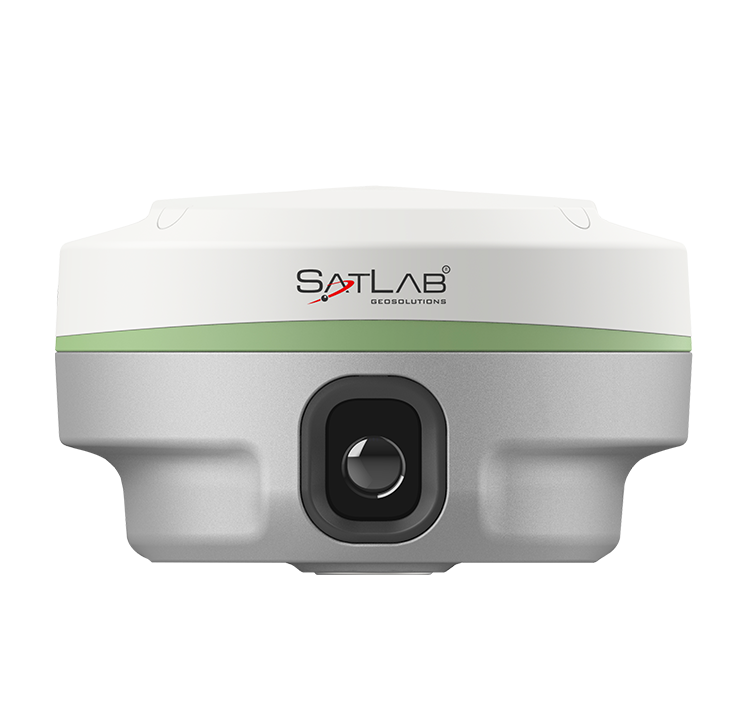
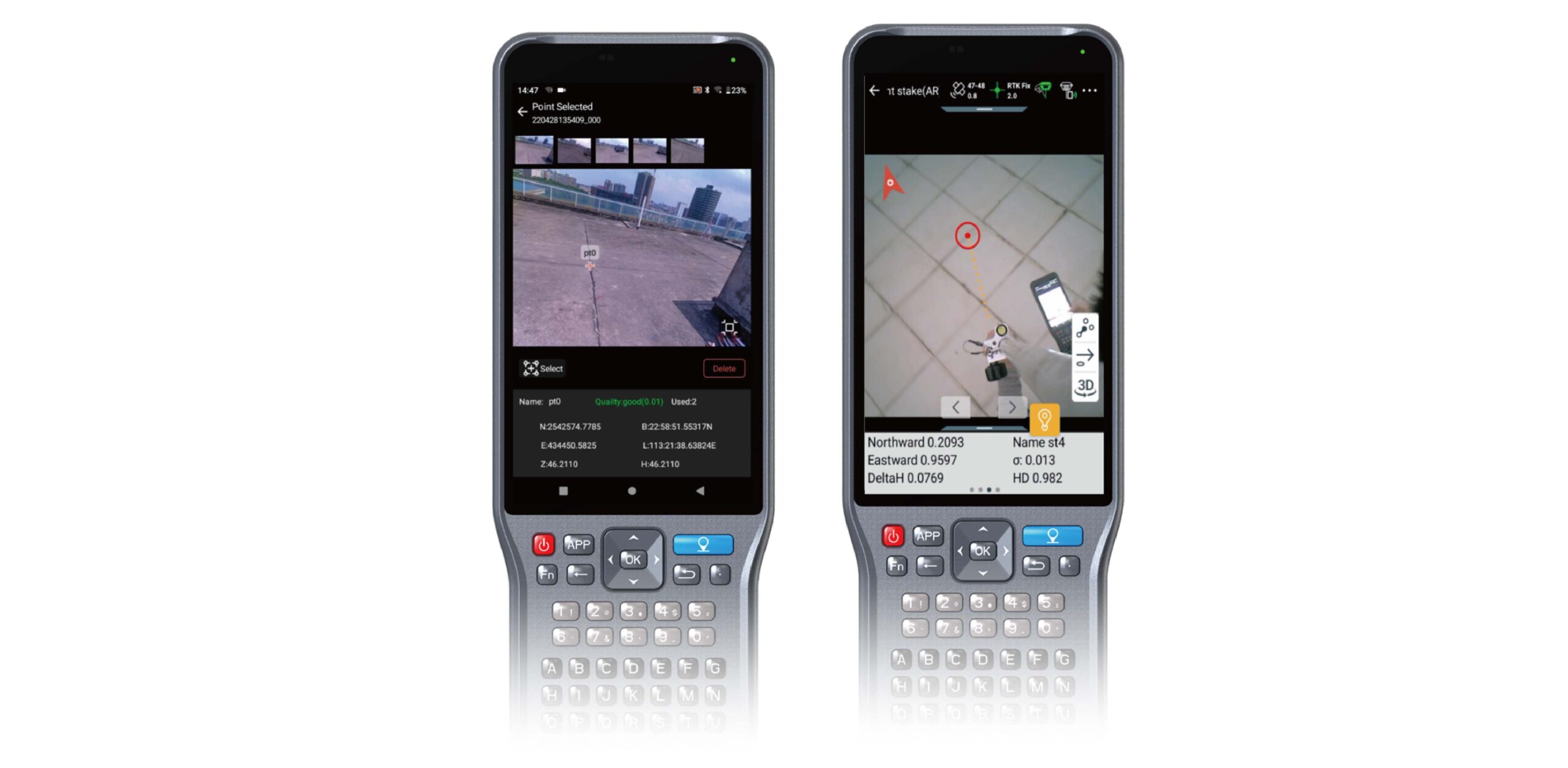
While there is some research background in the industry on combining cameras and RTKs, most of the previous “image RTK” were combination products, where the GNSS System Receiver and the camera were almost always used together in a separate unit. This was not only complicated to install, but also very inconvenient to carry.The design of a 360-degree camera for image positioning was achieved by installing multiple cameras at multiple angles to transmit images when the sensor was under development. Later on, image positioning technology was developed to meet the multi-angle measurement requirements in one camera. Two cameras have been creatively added to the rear and bottom of the receiver. The rear camera has 5MP to capture images during surveys and allows the user to zoom in and out; the bottom camera has 2MP for AR stakeout.by adding the receiver view, thus the stakeout accuracy stays below 3cm and the stakeout efficiency is increasing accordingly.
Triple novelty image application
Image survey, allowing you to unlock even more possibilities for measuring scenarios
Into such a well-developed era of computer technology, AR, UAV and other sensing technologies received widespread attention in society. the integration of imaging technology into all walks of life is the general trend, the integration of images into high-precision positioning instruments will be the key to break through the bottleneck of the previous traditional mapping scene. The non-contact measurement method is the biggest advantage that image positioning technology gives to GNSS RTK receivers. Highly integrated GNSS receiver products are becoming the mainstream products and the technology of combining IMU sensors with GNSS is well-developed. To analyze and process the images, the sensor needs to position with an accurate and robust 6DoF, which is able to detect changes in the up, down, front, back, left and right displacements due to overall movement, in addition to changes in field of view angle brought about by the rotation of the receiver. By adding a 6DoF sensing solution to the idea of acquiring position information from images, Satlab allows the customer to maintain sensitive camera gesture capture while moving as freely as possible, combined with close-up measurement techniques to produce more accurate positioning results.
360 panoramic switching AR stakeout, the controller and receiver work together to guide the stakeout process
Stakeout is one of the most commonly used functions in surveying and mapping projects.
Traditionally, it is time-consuming to complete numerous stakeout points in the field and maintain a high level of accuracy. However, prior to the introduction of Eyr, the only way to indicate a stakeout point in a live scene was through the controller’s rear camera, and it was impractical to fix the camera angle and height close to the stakeout point, so the user had to be guided to the stakeout point by a 3D animation. The Eyr bottom camera solves this problem by combining the bottom camera with the existing AR stakeout function. During the stakeout, the camera of the handheld controller can not only be used as a guide to the stakeout point, when the user is within a 1m range to the stakeout point, the camera view of the handheld controller will also switch 360 degrees to the bottom camera of the receiver. This combination helps the user reach the stakeout point quickly and improves stakeout efficiency greatly, ideally with an accuracy of up to 3cm.
Eyr, capable of 3D modeling application, will be a better choice for UAV and GNSS RTK receivers to work together
With its dual camera configuration, the Eyr not only overcomes many of the traditional barriers to measurement scenarios, but also allows for an easier and higher degree of freedom in the measurement process. The non-contact measurement and live-view AR stakeout are the main features of the Eyr as a measurement tool specifically for ground operations.
Equipped with the “eyes”, the Eyr receiver also plays an important role in UAV applications. The image data recorded by Satlab’s new Eyr can be simultaneously imported into the industry’s leading 3D modelling post-processing software for modelling operations, which is a good news for users with modelling needs.
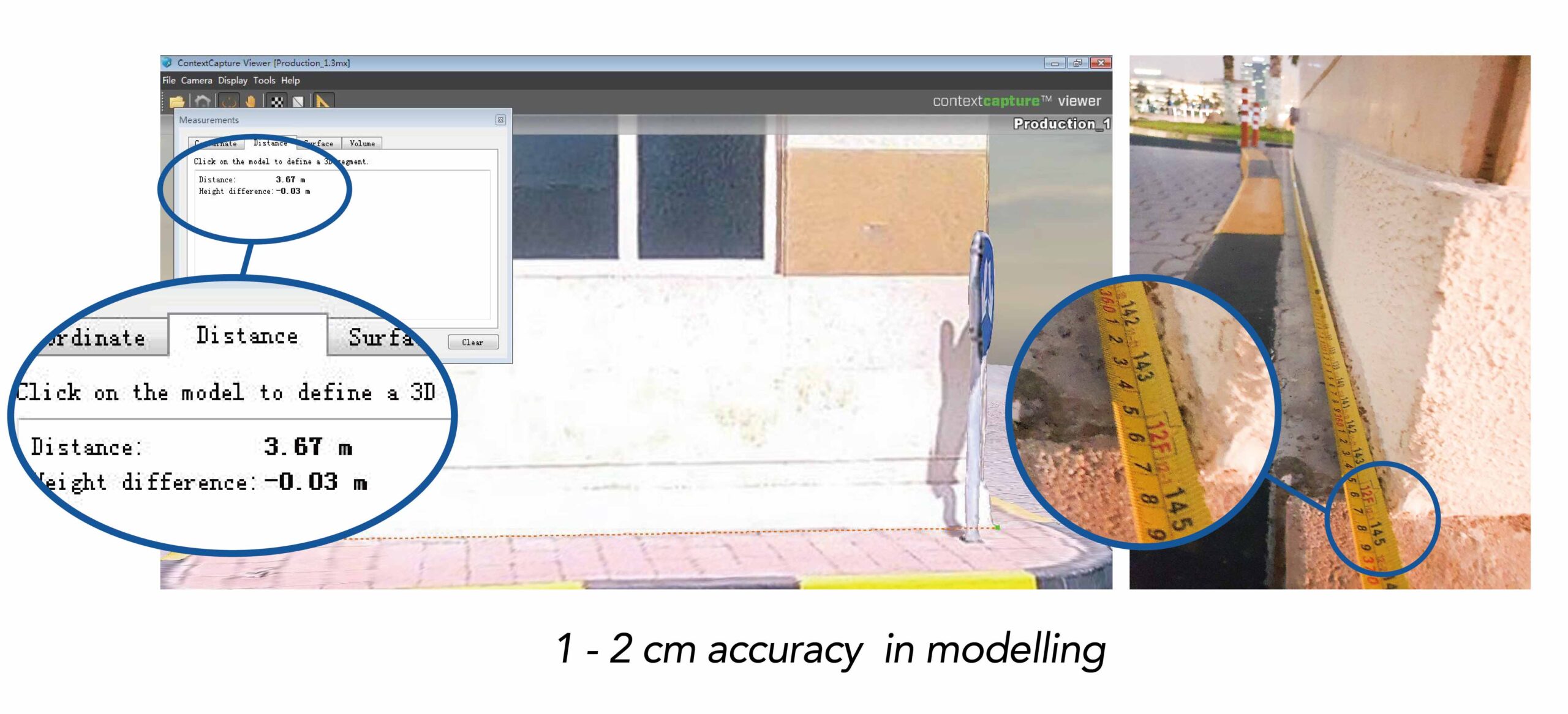 Eyr extends the application of more cases in satisfying the demands of various measurement situations. If freyja acts as a base station to provide the UAV with more accurate correction data to improve the accuracy of the deliverables and enhance the experience through better navigation, then Eyr serves as a collaborative tool to help the UAV obtain more image data on the ground. The image data captured by Eyr on the ground can be imported simultaneously into the software to complement the features that cannot be captured by the UAV in the air. This can help to obtain more complete 3D modelling data.